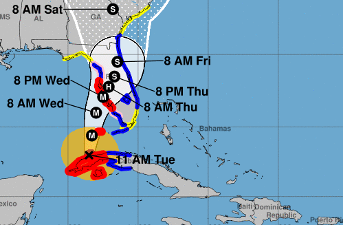
Hurricane Ian is moving toward Florida’s west coast and is expected to pass the Florida Keys later today. That’s according to the latest update from the National Hurricane Center. Ian is projected to hit the Gulf Coast side of Florida tomorrow into tomorrow evening. The storm’s maximum sustained winds are 115-miles-per-hour with even higher gusts. Forecasters say the storm will be an extremely dangerous major hurricane when it approaches the west coast of Florida.
Florida Governor Ron DeSantis says Hurricane Ian’s track is projecting to make landfall in the Sarasota region on the state’s Gulf Coast. DeSantis called the storm a major one and noted it’s currently a category three hurricane. The Governor said the storm will cause a major storm surge and water event that’ll lead to massive floods. He added evacuations have been ordered up and down the Gulf Coast, including the new projected landfall site of Sarasota. DeSantis said residents should expect to be without power due to strong winds that may knock over powerlines.
9/27 11am ET: Life-threatening storm surge from #Ian is increasingly likely along the Florida west coast where a storm surge warning is in effect, w/ the highest risk from Fort Myers to the Tampa Bay region. Listen to local officials & check https://t.co/0BMJEA5Wz0 for updates! pic.twitter.com/Yvimd5FMzT
— NHC Storm Surge (@NHC_Surge) September 27, 2022
Jacob Woods/sca Copyright © 2022 TTWN Media Networks Inc.


