
8:46 pm — Street flooding reported in Rose Hill, use caution. A wind gust of 75 mph was reported southwest of Rose Hill around 8:40 p.m.
8:41 pm — The latest from Country Stampede:
Due to severe thunderstorms, Stampede is on stand by until further notice. Please find shelter until the storm passes.
— Country Stampede (@Countrystampede) June 23, 2019
8:36 pm — Due to thunderstorms, Kicker Country Stampede is “on standby” in Topeka.
8:08 pm — Severe thunderstorm warning for Sedgwick, Butler and north central Sumner County until 9 p.m. Storms near Clearwater are moving northeast at 25 mph with 70 mph wind gusts possible.
3,355 without power in Wichita now.
Less than 67 without power now in Goddard.
El Dorado with 167 without power.
93 without power in Andover.
8:03 pm — 3,512 without power in Sedgwick Co.
7:48 pm — Flash Flood Warning including Anthony KS, Harper KS, Bluff City KS until 11:45 PM CDT
7:46 pm — New severe thunderstorm warning for Sedgwick, Harper, Kingman and Sumner counties until 8:45 p.m.
7:40 pm — The severe thunderstorm warning has been canceled for McPherson, Saline and Marion counties.
7:39 pm — Westar Energy has replied to us on Twitter, “Customers can get more specific information on their outage from the outage map at outagemap.westarenergy.com. However, it is likely there may be delays given the number of individual outages. -Megan”
7:19 pm — 1,710 without power throughout Sedgwick County right now.
1,047 without power in Wichita.
502 without power in Goddard.
7:08 pm — Westar Energy currently showing 1,355 customers without power in Sedgwick County.
67 mph wind gust confirmed at Eisenhower National Airport in Wichita.
7:05 pm — Reports of small branches down at 21st and Tyler. Be careful driving as branches could be laying in the roadways.
6:57 pm — Severe thunderstorm warning extended for all of Sedgwick, SE Harvey, and W Butler Co. This goes until 8:00 pm.
6:54 pm — 60-65 mph winds reported at Maize and Kellogg.
6:49 pm — Quarter size hail 2 miles SE of Goddard.
6:46 pm — Close to 600 without power in Goddard right now.
6:36 pm — Spotter reports wind gust of 70 mph northwest of Viola.
6:32 pm — Power is out in Goddard after wind gusts of 75 to 80 mph were reported with a thunderstorm.
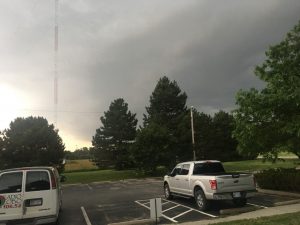
6:30 pm — We took this photo from the KFDI Studios looking southwest towards the storm that is coming eastward from Goddard.
6:16 pm — Severe thunderstorm warning for S McPherson, NE Reno, W Harvey, and West Central Marion Co until 7:15 pm
6:11 pm — Hail reports
Golf ball sized hail was reported northwest of Harper by a storm chaser. Penny sized hail was reported by a spotter north of Harper.
5:50 pm — Sedgwick County is under a severe thunderstorm warning
The NWS has issued a severe thunderstorm warning for SE Reno, W Sedgwick, NE Kingman, and NW Sumner counties until 6:45 p.m. Storm could produce 70 mph wind gusts and half-dollar-size hail.
5:23 pm — Severe storms are in Harper County moving northeast toward the Wichita area.

*The KFDI News team will continue to add to this story throughout the evening. Feel free to email us your storm/hail/damage photos to news@kfdi.com.